Itinerary
10 Days Rwenzori Hike ( 4 peaks Summit )
Day 1 : Start the hike from Trekkers Hotel 1450m to Sine Camp 2596m ( Distance 9.5km)
Considering that all Rwenzori Trekking via Kilembe route start from the trekkers hostel and its the best recommended accommodation for the first night and the last night, you will start at Trekkers at 1,450 meters and sleep at Sine Hut at 2,596 meters being a height gain of 1,146 meters.
 Trekking up the valley floor through tall forest trees of the Afro Montane Forest Zone. This is a steady climb with multitudes of birds and a chance of seeing blue monkeys scampering off through the forest. you may spot black and white Colobus monkeys, L’Hoest monkey. There is wide variety of plant species from forest trees to bamboos thickets, low shrubs, flowers, fungi, and with many moss and lichen covered vines hanging from the tall trees creating an awesome appeal. Enock’s Falls are just 200 meters from Sine Hut and offer a splendid opportunity to capture a great screensaver for your memories.
At Sine Camp 2,596 metres we have wooden huts set between tall forest trees on a narrow ridge where you may sit and enjoy the beauty of the Afro Montane forest while you look down at a fantastic waterfall crashing over the rocks far below.
Day 2: Sine Camp 2596m to Mutinda Camp 3588m ( Distance 6.1km)
 Trekking starts at 8.30am and almost immediately you enter the Bamboo-Mimulopsis Zone which is steep climb with many high steps. In the wet season the bamboo zone is rather muddy and slippery making the going slow. However, the atmosphere and the forest is beautiful as you climb 551 metres altitude and a distance of 1.8km to Kalalama Camp at 3,147 meters which is in the Heather-Rapanea Zone where you can take a rest and a quick cup of tea or coffee before heading on to Mutinda Camp. The trail meanders up and over several small knolls along a ridge top then drops down the side of the valley before climbing again, and in doing so cross several small streams and pass close to moss covered waterfalls. You then climb steadily along the side of a beautiful mossy river which tumbles down over the rocks under the Giant Heather trees whose trunks are covered in green moss with old man beards (Usnea lichen) hanging from the branches. The trail twists and turns as you climb up the deep valley, which has an enormous variety of plants and flowers. This valley is unique with many Giant Heather trees creating a beautiful atmosphere often shrouded in mist.
In the afternoon, you may wish to climb up to the top of the Mutinda Lookout (one to two hours up and one hour down) The views are amazing as you stand on moss covered rocks at 3,925 meters with views across the Rwenzori Mountains and down to Kasese town and Lake George. For those clients who are climbing to Margherita or any of the main peaks climbing Mutinda 3,975 meters is also an excellent way to acclimatize and reduce the risk of high altitude sickness
Sleep at Mutinda Camp at 3.588 metres
Day 3: Mutinda Camp 3588m to Bugata Camp 4062m ( Distance 8.6kms)
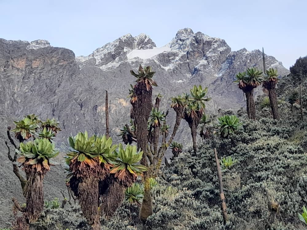
The trail to Bugata Camp is boggy particularly in the wet season but with a little skill you can step from tussock to tussock to make the going easier. First you cross the Mutinda valley through the tussock grass and everlasting flowers interspersed with many Giant Lobelias before climbing a steep section up to the Namusangi Valley (3,840 meters), with sheer waterfalls and looking back you get fantastic views of Mutinda Peaks. The Namusangi Valley is wide, with many ups and downs as the trail climbs steadily to Bugata Camp at 4,100 metres.
Day 4: Bugata Camp 4062m to Hunwick Camp 3974m via via Bamwanjara 4.45om ( Distance 8.3km)
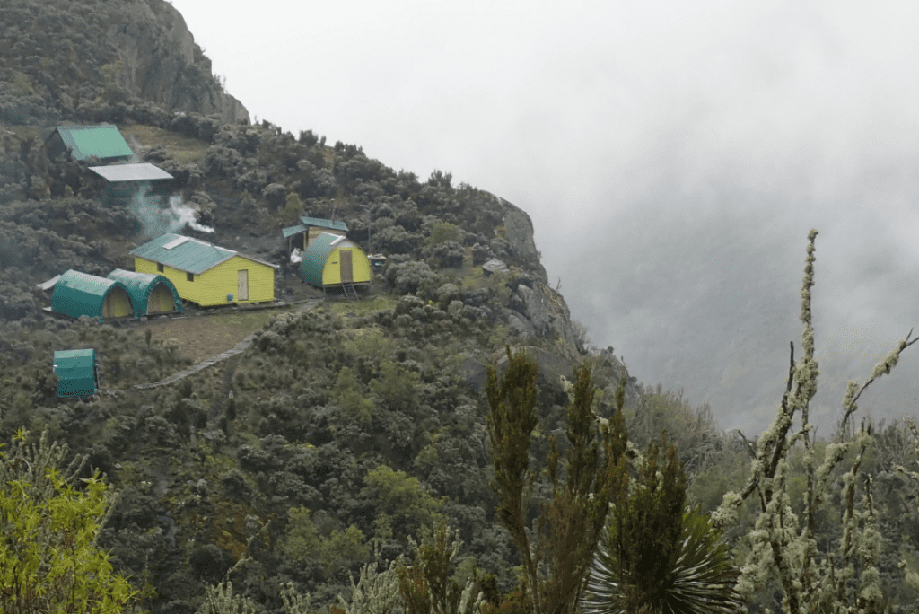 Trek to Hunwick’s Camp via Bamwanjarra Pass. As you leave Bugata Camp you pass up a ridge then drop down slightly before ascending to Bamwanjarra Pass at 4,450 meters where we have a hut should the weather turn bad. From the pass on a clear day you get excellent views of the three main peaks. The trail passes down the valley and around the edge of some bogs and thick ever green vegetation, moss. giant groundsel and lobelia. Here is possibly the best place in all the Rwenzori to observe the Malachite Sunbird as it feeds on the many lobelia flowers and a known breeding site. Farther on there is some steep sections before a steady climb up and over a ridge to Hunwick’s Camp which is situated on the top of a deep valley and has good views of Mt Stanley, Mt Baker, Weismann’s Peak and McConnell’s Prong.
Day 5: Hunwick Camp 3974m to Climb Mount Baker and Back to Hunwick Camp ( Distance 8.4kms)
4.3 kilometer climb 4 to 6 hours up and 2 to 3 hours back down. Set off by 6.30am to climb the Mt Baker Peak 4,842 metres. Ascent time from McConnell’s Camp (Camp 4) to the top is three to four hours and descent three hours. This is a steep rocky climb where you need a good head for heights as some sections like the crevice climbing down to the glacier has a sizeable drop off the side. Although steep Mt Baker is considered non-technical except in the snow season (wet season) of April-May and September-October when it is very slippery on the ice-covered rocks, nevertheless safety ropes will be used at all times on steep sections. After climbing up you descend along a crack in the rock face to the glacier and a short 300 metre walk to the peak.
If we have fine weather or a break in the cloud the views of the main peaks of Magherita, Alexandria, Stanley’s plateau and the glaciers are fantastic as you see the splendor of these beautiful snow capped mountains. The view is awesome!! After absorbing this lifetime experience we walk back across the glacier climb back up the crack in the rock face and descend to McConnell’s Camp. Sleep at Camp 4.
Day 6: Hunwick Camp3975m to Margherita Camp4,485m ( Distance 5.1km
Hike to Margherita camp at 4485 meters, passing down and across the valley floor to Lake Kitandara which is very stunning with deep water and beautiful vegetation, climbing through Scoot Elliot pass to Margherita camp. Meals: B, L, D
Day 7: Margherita Camp 4,485m to Margherita Peak5,109m and proceed to Bujuku Caves ( distance 13.1 km)
 Wake up at 1:30am and catch an early breakfast before heading off to climb Mt Stanley at 2.00am. Climb up to Stanley plateau where you cross the first glacier before descending to the base of Margherita glacier. The lower part of the glacier is steep and low level technical hence using ropes and belays. On reaching near to the top of the glacier you have some steep rocky climbs for about 60metres to get up to the ridge heading to Margherita peak at 5109metres. descending the glacier down past Irene lake to Bujuku valley crossing a long bog to the base of Mt Speke 4890metres where you will rough camp in a small rock shelter.
Day 8: Bujuku Caves to Mount Speke 4,890m and descend to Hunwick Camp 3975m (distance 16.1km
Climb upto Mt Speke 4890metres then return to cross the Bujuku valley and climb up to Scott Elliot pass and down to Hunwick’s Camp 3974metres.
Day 9: Hunwick camp 3975m to Kiharo Camp 3,430m ( Distance 15.8km)
From Hunwicks Camp we start the day by climbing up a ridge towards McConnell’s Prong where you get the best views of all three peaks and Scott Elliott’s Pass before reaching Oliver’s Pass at 4,505 Metres. The distance from Hunwick’s Camp to the top of Oliver’s Pass is 3km The trail then cuts across below Weismann’s Peak to the confluence of the Nyamwamba River. You can opt to take on the summit of Weismann’s peak for those that will still be strong enough coming down and continue to Kiharo camp at 3430 meters. Overnight at Kiharo Camp, set in a deep valley with high cliffs and dense vegetation. Meals: B, L, D
Day 10 : Kiharo Camp 3,430m to Park Gate 1720m ( Distance 16 kms
Distance Kiharo Camp to the park gate 12.2km and another 2.8km down to Trekkers Hostel Time to walk 5 to 8 hours so those who need to connect to flights back to Kampala or travel on to other activities need to leave Kiharo early.
The trail down the Nyamwamba Valley is mostly downhill and absolutely stunning with beautiful views, moss covered rocks along the river, cascading waterfalls, deep valleys and forests are possibly the best in the Rwenzori Mountains. This part of the trail took us six years to find a way through and a route which is easy enough for tourists to use. In 1937 the explorer and geologist McConnell tried to find a way up this valley but failed and have to turn back and search for another route up the mountain but now you can experience this truly beautiful valley. Debrief and awarding of certificates.
